Tuesday, November 30, 2010

Check-in/OK message from S/Y Juno SPOT Personal Tracker

S/Y Juno
Latitude:14.16152
Longitude:-26.78613
GPS location Date/Time:11/30/2010 22:27:30 GMT

Message:Juno's latest position:

Click the link below to see where I am located.
http://fms.ws/3vT0C/14.16152/\-26.78613

If the above link does not work, try this link:
http://maps.google.com/maps?f=q&hl=en&geocode=&q=14.16152,-26.78613&ll=14.16152,-26.78613&ie=UTF8&z=12&om=1

S/Y Juno

You have received this message because S/Y Juno has added you to their SPOT contact list.

Every day is an Adventure. Share Yours.
http://www.findmespot.com

Check-in/OK message from S/Y Juno SPOT Personal Tracker

S/Y Juno
Latitude:14.81269
Longitude:-26.27182
GPS location Date/Time:11/30/2010 11:48:34 GMT

Message:Juno's latest position:

Click the link below to see where I am located.
http://fms.ws/3vJh9/14.81269/\-26.27182

If the above link does not work, try this link:
http://maps.google.com/maps?f=q&hl=en&geocode=&q=14.81269,-26.27182&ll=14.81269,-26.27182&ie=UTF8&z=12&om=1

S/Y Juno

You have received this message because S/Y Juno has added you to their SPOT contact list.

Every day is an Adventure. Share Yours.
http://www.findmespot.com

Monday, November 29, 2010

Check-in/OK message from S/Y Juno SPOT Personal Tracker

S/Y Juno
Latitude:15.06953
Longitude:-25.5899
GPS location Date/Time:11/29/2010 21:10:01 GMT

Message:Juno's latest position:

Click the link below to see where I am located.
http://fms.ws/3vB4i/15.06953/\-25.5899

If the above link does not work, try this link:
http://maps.google.com/maps?f=q&hl=en&geocode=&q=15.06953,-25.5899&ll=15.06953,-25.5899&ie=UTF8&z=12&om=1

S/Y Juno

You have received this message because S/Y Juno has added you to their SPOT contact list.

Every day is an Adventure. Share Yours.
http://www.findmespot.com

Check-in/OK message from S/Y Juno SPOT Personal Tracker

S/Y Juno
Latitude:14.85345
Longitude:-25.06976
GPS location Date/Time:11/29/2010 13:02:49 GMT

Message:Juno's latest position:

Click the link below to see where I am located.
http://fms.ws/3v3sM/14.85345/\-25.06976

If the above link does not work, try this link:
http://maps.google.com/maps?f=q&hl=en&geocode=&q=14.85345,-25.06976&ll=14.85345,-25.06976&ie=UTF8&z=12&om=1

S/Y Juno

You have received this message because S/Y Juno has added you to their SPOT contact list.

Every day is an Adventure. Share Yours.
http://www.findmespot.com

Hmmm . . . Maybe we won't be going in for bread this morning after all

Insofar as 3-meter breakers are crashing onto the slipway. And the locals are filling sandbags for the seawall.

Perhaps it's time to head to Barbados.
Sent via BlackBerry by AT&T

Sunday, November 28, 2010

Pickup truck ride for the very first time ever in my life.

Up till today, I've never ridden on the back of a pickup truck. You see, the taxis that you can get on the island of Brava are-well-"taxi" is kind of an misnomer. They are all pickup trucks. As much as it is unsafe, you don't get carsick because there's so much apparent wind. And you are jostled around so much. I had to hold onto a beam. I hope that I don't have to do it again.
--By Rigel
Sent via BlackBerry by AT&T

A Crazy Dinghy Adventure

A Crazy Dinghy Adventure

Today we moved from our former anchorage to this other one, and it actually has a town. The only problem preventing us from going ashore and getting groceries and exploring was the swell. It is big enough in this anchorage to prevent an easy landing, so we had to time our rush for the ramp by the swell. We made a total fiasco out of it. We completely mistimed the swell and got hurled towards some rocks. We did hit hem,. But they didn't cause any serious damage to the dinghy. Then we scrambled out, grabbed the dinghy, and tried to pull it ashore. Then we got scattered by another breaking wave, got back to the dinghy, and managed to get it up onto the concrete ramp. After that it was only a matter of carrying the dinghy up to a safe spot, and getting a taxi up into town. When we got back, we were faced with a bigger swell, cold water, and the sun going down. Luckily we had the help of several of the inhabitants willing to help us. Unlike us, they knew how to time the swell, and helped us get back to the boat safely. It was one of the few situations this trip that really got the adrenaline pumping in me, and I sincerely hope that next time we will be more careful and successful.
--Orion Date
Sent via BlackBerry by AT&T

Our anchorage at Faja de Agua

Looks peaceful from here, no? Look closely at the breakers. Look at how they've grown since we brought the dinghy ashore.

A dinghy launching experience we DON'T want to repeat.

Muito obrigado to our Cape Verdean friends who helped us get in and through the breakers, including one elder gent who has no doubt seen many, many days much rougher than this. Muito obrigado.
Sent via BlackBerry by AT&T

Juno at anchor in Faja de Agua

Surging back and forth, back and forth, on waves from a storm a thousand miles away.
Sent via BlackBerry by AT&T

How

Did we possibly land the dinghy on a concrete slipway in a 2-meter swell?

Don't ask. It wasn't pretty.
Sent via BlackBerry by AT&T

Approaching Brava

The southwestern-most of the Cape Verde Islands. Getting positioned for the jump across.
Sent via BlackBerry by AT&T

Sunday afternoon futbol

In Nova de Sintra.
Sent via BlackBerry by AT&T

Check-in/OK message from S/Y Juno SPOT Personal Tracker

S/Y Juno
Latitude:14.87301
Longitude:-24.73215
GPS location Date/Time:11/28/2010 11:03:13 GMT

Message:Juno's latest position:

Click the link below to see where I am located.
http://fms.ws/3unmZ/14.87301/\-24.73215

If the above link does not work, try this link:
http://maps.google.com/maps?f=q&hl=en&geocode=&q=14.87301,-24.73215&ll=14.87301,-24.73215&ie=UTF8&z=12&om=1

S/Y Juno

You have received this message because S/Y Juno has added you to their SPOT contact list.

Every day is an Adventure. Share Yours.
http://www.findmespot.com

Saturday, November 27, 2010

Check-in/OK message from S/Y Juno SPOT Personal Tracker

S/Y Juno
Latitude:14.8321
Longitude:-24.73859
GPS location Date/Time:11/27/2010 15:52:26 GMT

Message:Juno's latest position:

Click the link below to see where I am located.
http://fms.ws/3uYpH/14.8321/\-24.73859

If the above link does not work, try this link:
http://maps.google.com/maps?f=q&hl=en&geocode=&q=14.8321,-24.73859&ll=14.8321,-24.73859&ie=UTF8&z=12&om=1

S/Y Juno

You have received this message because S/Y Juno has added you to their SPOT contact list.

Every day is an Adventure. Share Yours.
http://www.findmespot.com

Thursday, November 25, 2010

Check-in/OK message from S/Y Juno SPOT Personal Tracker

S/Y Juno
Latitude:15.76207
Longitude:-24.18839
GPS location Date/Time:11/26/2010 02:35:37 GMT

Message:Juno's latest position:

Click the link below to see where I am located.
http://fms.ws/3u8Q4/15.76207/\-24.18839

If the above link does not work, try this link:
http://maps.google.com/maps?f=q&hl=en&geocode=&q=15.76207,-24.18839&ll=15.76207,-24.18839&ie=UTF8&z=12&om=1

S/Y Juno

You have received this message because S/Y Juno has added you to their SPOT contact list.

Every day is an Adventure. Share Yours.
http://www.findmespot.com

Check-in/OK message from S/Y Juno SPOT Personal Tracker

S/Y Juno
Latitude:16.64773
Longitude:-23.08295
GPS location Date/Time:11/25/2010 11:50:18 GMT

Message:Juno's latest position:

Click the link below to see where I am located.
http://fms.ws/3ty8v/16.64773/\-23.08295

If the above link does not work, try this link:
http://maps.google.com/maps?f=q&hl=en&geocode=&q=16.64773,-23.08295&ll=16.64773,-23.08295&ie=UTF8&z=12&om=1

S/Y Juno

You have received this message because S/Y Juno has added you to their SPOT contact list.

Every day is an Adventure. Share Yours.
http://www.findmespot.com

Tuesday, November 23, 2010

The exploding candle

On my birthday, I got a candle. And a whole lot of other stuff, mostly computer stuff, but the candle was rather interesting. For it was in the shape of a closed flower, and on the tips of the pedals, pointing inward, were tiny candles. There was no wick in the center on the flower. Well, when we got around to using it, we got a lighter, and lit all of the wicks. It looked like a torch for a while. Then, most of the petals opened up. We pushed open the two that didn't. Edee got her fingers out of the way when an afterburner-looking flame erupted out of the center of the now open flower. Some sparks came out, and it stopped. Right then, the box said that it was supposed to play music. I half expected a little play button to come out. None did.


--By Rigel
Sent via BlackBerry by AT&T

Finding us a sandy spot...

Sent via BlackBerry by AT&T

Check-in/OK message from S/Y Juno SPOT Personal Tracker

S/Y Juno
Latitude:16.6961
Longitude:-22.97177
GPS location Date/Time:11/23/2010 12:43:35 GMT

Message:Juno's latest position:

Click the link below to see where I am located.
http://fms.ws/3tKcD/16.6961/\-22.97177

If the above link does not work, try this link:
http://maps.google.com/maps?f=q&hl=en&geocode=&q=16.6961,-22.97177&ll=16.6961,-22.97177&ie=UTF8&z=12&om=1

S/Y Juno

You have received this message because S/Y Juno has added you to their SPOT contact list.

Every day is an Adventure. Share Yours.
http://www.findmespot.com

Monday, November 22, 2010

Wheelbarrow Water

Wheelbarrow Water

All the water that they use here was once seawater. It was taken into a desalination plant and desalinated (had the salt removed). Our own water comes from a similar source, our reverse osmosis watermaker. I don't know if the desalination plant on shore is reverse osmosis, but it does turn seawater into fresh water. This island is currently experiencing a drought, and has been for some time. There is no running water, everyone has to go the public water supply and lug it home in wheelbarrows or something similar. I can't imagine what it must be like to have to carry all the water you use from the town supply to your house. I have a semi-similar view seeing as we are on a sailboat and have to conserve water in everything we do, from taking showers to washing dishes. We don't, however, have to carry it all several blocks. It helps to reflect the lifestyle of the people living here to watch them carrying these huge water containers in wheelbarrows.
--Orion Date
Sent via BlackBerry by AT&T

Saturday, November 20, 2010

Walking the streets of Espargos

The "big city" of Sal. Looking, naturally, for Cheerios and tri-color rotini.
Sent via BlackBerry by AT&T

Friday, November 19, 2010

From La Palma to Sal

From La Palma to Sal

This was one of our rougher passages so far. It wasn't the roughest, that was our little jaunt to the Bahamas early last year. It was, however, moderately rough. At least for the middle part it was. During that time I was seriously sick. I haven't been seriously sick for quite a while. I guess it must have been the Sibari-Ithaca jump. I think I was a little seasick on the way to the Canaries, but that was just not eating. This was genuine seasickness. I hadn't felt that was for months, and I absolutely hated it. The first day was fine, pretty calm, and I managed to do schoolwork. Then it was rough for two days. After that it started to calm down, but I didn't totally recover until the next day. The port we are anchored in is called Palmeira, on the west coast of the island Sal, in the Cape Verde Islands. I don't know how long we are staying here, but it's really nice to finally be able to swim again.
--Orion Date
Sent via BlackBerry by AT&T

Bathing on Juno

Bathing to you may seem very simple to you, but it means more than that to us. It involves jumping in the water, for one thing. Note that this is only when we are at anchor, otherwise the water is filthy. After you jump in, you get out, and shampoo all over yourself (you can only use baby shampoo with seawater). You jump back in, get out, and rinse off in something called a sun shower. It uses the sun to heat up fresh water. It's really cool.
--By Rigel
Sent via BlackBerry by AT&T

Customs cleared, dousing the Q flag

Sent via BlackBerry by AT&T

And goodbye Columbus

La Gomera, from whence the Admiral of the Ocean departed for India, September 1492.
Sent via BlackBerry by AT&T

Thursday, November 18, 2010

Check-in/OK message from S/Y Juno SPOT Personal Tracker

S/Y Juno
Latitude:18.62467
Longitude:-22.33728
GPS location Date/Time:11/18/2010 11:21:41 GMT

Message:Juno's latest position:

Click the link below to see where I am located.
http://fms.ws/3ri6a/18.62467/\-22.33728

If the above link does not work, try this link:
http://maps.google.com/maps?f=q&hl=en&geocode=&q=18.62467,-22.33728&ll=18.62467,-22.33728&ie=UTF8&z=12&om=1

S/Y Juno

You have received this message because S/Y Juno has added you to their SPOT contact list.

Every day is an Adventure. Share Yours.
http://www.findmespot.com

Wednesday, November 17, 2010

Check-in/OK message from S/Y Juno SPOT Personal Tracker

S/Y Juno
Latitude:20.56504
Longitude:-21.18378
GPS location Date/Time:11/17/2010 11:18:18 GMT

Message:Juno's latest position:

Click the link below to see where I am located.
http://fms.ws/3rNHh/20.56504/\-21.18378

If the above link does not work, try this link:
http://maps.google.com/maps?f=q&hl=en&geocode=&q=20.56504,-21.18378&ll=20.56504,-21.18378&ie=UTF8&z=12&om=1

S/Y Juno

You have received this message because S/Y Juno has added you to their SPOT contact list.

Every day is an Adventure. Share Yours.
http://www.findmespot.com

Tuesday, November 16, 2010

Check-in/OK message from S/Y Juno SPOT Personal Tracker

S/Y Juno
Latitude:22.7709
Longitude:-20.13278
GPS location Date/Time:11/16/2010 11:44:44 GMT

Message:Juno's latest position:

Click the link below to see where I am located.
http://fms.ws/3r3zp/22.7709/\-20.13278

If the above link does not work, try this link:
http://maps.google.com/maps?f=q&hl=en&geocode=&q=22.7709,-20.13278&ll=22.7709,-20.13278&ie=UTF8&z=12&om=1

S/Y Juno

You have received this message because S/Y Juno has added you to their SPOT contact list.

Every day is an Adventure. Share Yours.
http://www.findmespot.com

Monday, November 15, 2010

Check-in/OK message from S/Y Juno SPOT Personal Tracker

S/Y Juno
Latitude:25.15867
Longitude:-19.11526
GPS location Date/Time:11/15/2010 11:11:27 GMT

Message:Juno's latest position:

Click the link below to see where I am located.
http://fms.ws/3ql-m/25.15867/\-19.11526

If the above link does not work, try this link:
http://maps.google.com/maps?f=q&hl=en&geocode=&q=25.15867,-19.11526&ll=25.15867,-19.11526&ie=UTF8&z=12&om=1

S/Y Juno

You have received this message because S/Y Juno has added you to their SPOT contact list.

Every day is an Adventure. Share Yours.
http://www.findmespot.com

Sunday, November 14, 2010

Check-in/OK message from S/Y Juno SPOT Personal Tracker

S/Y Juno
Latitude:25.96861
Longitude:-18.60532
GPS location Date/Time:11/15/2010 01:35:39 GMT

Message:Juno's latest position:

Click the link below to see where I am located.
http://fms.ws/3qgVC/25.96861/\-18.60532

If the above link does not work, try this link:
http://maps.google.com/maps?f=q&hl=en&geocode=&q=25.96861,-18.60532&ll=25.96861,-18.60532&ie=UTF8&z=12&om=1

S/Y Juno

You have received this message because S/Y Juno has added you to their SPOT contact list.

Every day is an Adventure. Share Yours.
http://www.findmespot.com

Check-in/OK message from S/Y Juno SPOT Personal Tracker

S/Y Juno
Latitude:26.88146
Longitude:-18.1442
GPS location Date/Time:11/14/2010 11:30:09 GMT

Message:Juno's latest position:

Click the link below to see where I am located.
http://fms.ws/3qRlC/26.88146/\-18.1442

If the above link does not work, try this link:
http://maps.google.com/maps?f=q&hl=en&geocode=&q=26.88146,-18.1442&ll=26.88146,-18.1442&ie=UTF8&z=12&om=1

S/Y Juno

You have received this message because S/Y Juno has added you to their SPOT contact list.

Every day is an Adventure. Share Yours.
http://www.findmespot.com

Saturday, November 13, 2010

Check-in/OK message from S/Y Juno SPOT Personal Tracker

S/Y Juno
Latitude:27.67682
Longitude:-17.70676
GPS location Date/Time:11/14/2010 01:23:25 GMT

Message:Juno's latest position:

Click the link below to see where I am located.
http://fms.ws/3qLhn/27.67682/\-17.70676

If the above link does not work, try this link:
http://maps.google.com/maps?f=q&hl=en&geocode=&q=27.67682,-17.70676&ll=27.67682,-17.70676&ie=UTF8&z=12&om=1

S/Y Juno

You have received this message because S/Y Juno has added you to their SPOT contact list.

Every day is an Adventure. Share Yours.
http://www.findmespot.com

Saying bye to Las Islas Canarias

Including El Tiede, the tallest mountain in Spain, on Tenerife.
Sent via BlackBerry by AT&T

Check-in/OK message from S/Y Juno SPOT Personal Tracker

S/Y Juno
Latitude:28.63102
Longitude:-17.7225
GPS location Date/Time:11/13/2010 14:01:09 GMT

Message:Juno's latest position:

Click the link below to see where I am located.
http://fms.ws/3q78G/28.63102/\-17.7225

If the above link does not work, try this link:
http://maps.google.com/maps?f=q&hl=en&geocode=&q=28.63102,-17.7225&ll=28.63102,-17.7225&ie=UTF8&z=12&om=1

S/Y Juno

You have received this message because S/Y Juno has added you to their SPOT contact list.

Every day is an Adventure. Share Yours.
http://www.findmespot.com

Was the Santa Maria really that tiny?

Sent via BlackBerry by AT&T

Our last morning in La Palma

Sent via BlackBerry by AT&T

Friday, November 12, 2010

An Island Tour

Almost the whole of yesterday was spent driving around the island.
First, we started to drive up to the observatory on the rim of the
caldera. Then we discovered that we were low on gas. I took a look at
the map and figured out that there were no gas stations on the road we
were on. So we had to turn around and go to another town for gas, then
we were able to head up to the observatory. It was not easy to drive up
there, but Dad managed, and eventually we drove right up into the
clouds. Because of the shape of the island, the eastern side is almost
always cloudy. When we suddenly popped out of the top of the cloud, the
sight was incredible. The whole ocean seemed to be made of clouds. We
were so low to the cloud layer that it seemed to have no end. Then we
saw the observatory. It was not how you would imagine, with one huge
circular building with a domed roof. Instead it was a number of these
domes and two big reflector dishes made of dozens of smaller mirrors all
working as one. Nearby was a trail that we walked along until we found a
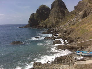
vantage point of the entire caldera. In all of my life I have never seen
a landscape as jagged and steep as this. We were on top of a thin ridge
that curved around in a circle with a huge canyon leading outwards to
the sea. We drove around the caldera rim for some time, until we got to
the road leading to Los Llanos, the biggest city on the island. There,
we promptly got lost. We were in a maze of streets, with a map that only
showed the bigger roads. We searched for the correct road for the better
part of an hour, before finally heading up into the caldera. I really
don't think that the long and difficult drive was really worth it. It
was extremely narrow and impossible to see around the curves. We were
lucky and didn't meet any cars an the way up or down, but the view
really wasn't worth the effort. Then we drove down to the southern tip
of the island. We got lost a second time trying to see the new volcano
that erupted only forty years ago in 1971. We found our way back to the
coastal roads after another half hour, and saw the huge new banana
plantation on the lava flows from that recent eruption. We saw the
lighthouse on the southernmost point, then finally went back to the boat
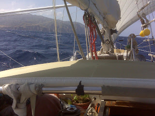
after a truly exhausting but exciting day.
--Orion Date

Thursday, November 11, 2010

At the southern tip

By the old lighthouse, blackened in the 1971 eruption, and the new.
Sent via BlackBerry by AT&T

Driving across the streambed

Of the world's largest caldera. Past the world's largest boulder.
Sent via BlackBerry by AT&T

Finally, at the elusive lookout point

WAY up a loooonnnng, twisty, narrow, steep road. LP-214, for those tracking on Mapquest.
Sent via BlackBerry by AT&T

At the top -- Roque de Los Muchachos

2426 meters. Nearly 8,000 feet. Which is why La Palma is the steepest island in the world.
Sent via BlackBerry by AT&T

See what we mean?

Just don't look down!
Sent via BlackBerry by AT&T

The most rugged terrain

Ever. Anywhere. In the whole universe.
Sent via BlackBerry by AT&T

What? What do you mean we can't play with the telescopes!

We're named after celestial objects for Jupiter's sake!
Sent via BlackBerry by AT&T

The most rugged caldera to date

On Juno's volcanic island tour.
Sent via BlackBerry by AT&T

And then above and out

Sent via BlackBerry by AT&T

Driving into the clouds

Sent via BlackBerry by AT&T

Wednesday, November 10, 2010

Something Else to Replace

Two more things to be exact, but these are not at all required for the
boat to function properly. The first is a new kitchen timer. Our current
one has been malfunctioning for some time, with various buttons refusing
to work. At the moment, it only refuses to clear, but that isn't to much
of a problem. The real problem is when it doesn't let us start or stop
it, or not work at all. We've been looking for one, but all we've found
are little cheap mechanical ones. The other object in need of
replacement is our pepper grinder. This one is about to literally fall
apart, so we have been looking into various stores to find a new one. It
needs to be refillable, but most are, and it shouldn't be a problem.
Tomorrow we will be making a tour of the island, most specifically the
huge volcanic caldera in the center.
--Orion Date

Pioneer plants

When we were walking along the volcano, I saw a lava bomb[wiki] that had a tiny green plant growing in it. This may not be very strange to you, but a plant in a large rock is very unusual, don't you think? Anyway, that plant will make a crack, allowing more plants to get in, they break down rocks to make fertile soil (volcanic soil is the most fertile) which will allow even more plants to get in, and then, well, you get the idea.


--By Rigel

Another cloudy afternoon

In Santa Cruz de La Palma.
Sent via BlackBerry by AT&T

Tuesday, November 9, 2010

Walking another volcano

Sent via BlackBerry by AT&T

And for good measure. . .

A wine tasting at a lava soil bodega. Daddy's first ever.

So are you obliged to buy a bottle at these things?
Sent via BlackBerry by AT&T

Monday, November 8, 2010

La Palma

Not to be confused with Las Palmas, the big port on Grand Canaria. La
Palma is an island in the Canary Islands. We got into Marina la Palma
this morning around 10:00 A.M., refueled, and moved to the slip that we
were assigned. It is a very nice marina. Apparently it's almost brand
new. The bathrooms are spotless, as are the showers, and the only bad
thing is the surge. According to Dad, when the wind goes into the east,
the swell gets into the harbor, causing a slight surge in the marina.
It's nothing serious, but it does make it a bit uncomfortable. We'll be
going into town later today, and hopefully we'll find a good supermarket
close by.
--Orion Date

La Palma

--Orion Date

Marinas

 For the last few months, we've hopping from marina to marina. It's a lot more comfortable than in a harbor. Lots less to worry about, too. No worries about dragging. I sleep better in marinas. We also get electricity. And water. And (sometimes) WiFi. That's how I'm uploading this post.


--By Rigel


Nearing La Palma

A green island, for a change.
Sent via BlackBerry by AT&T

Sunday, November 7, 2010

Check-in/OK message from S/Y Juno SPOT Personal Tracker

S/Y Juno
Latitude:28.79194
Longitude:-16.92117
GPS location Date/Time:11/08/2010 01:17:15 GMT

Message:Juno's latest position:

Click the link below to see where I am located.
http://fms.ws/3oKAf/28.79194/\-16.92117

If the above link does not work, try this link:
http://maps.google.com/maps?f=q&hl=en&geocode=&q=28.79194,-16.92117&ll=28.79194,-16.92117&ie=UTF8&z=12&om=1

S/Y Juno

You have received this message because S/Y Juno has added you to their SPOT contact list.

Every day is an Adventure. Share Yours.
http://www.findmespot.com

Check-in/OK message from S/Y Juno SPOT Personal Tracker

S/Y Juno
Latitude:28.85185
Longitude:-16.16064
GPS location Date/Time:11/07/2010 16:56:00 GMT

Message:Juno's latest position:

Click the link below to see where I am located.
http://fms.ws/3oAwu/28.85185/\-16.16064

If the above link does not work, try this link:
http://maps.google.com/maps?f=q&hl=en&geocode=&q=28.85185,-16.16064&ll=28.85185,-16.16064&ie=UTF8&z=12&om=1

S/Y Juno

You have received this message because S/Y Juno has added you to their SPOT contact list.

Every day is an Adventure. Share Yours.
http://www.findmespot.com

Check-in/OK message from S/Y Juno SPOT Personal Tracker

S/Y Juno
Latitude:28.82874
Longitude:-15.68945
GPS location Date/Time:11/07/2010 11:01:24 GMT

Message:Juno's latest position:

Click the link below to see where I am located.
http://fms.ws/3o6J7/28.82874/\-15.68945

If the above link does not work, try this link:
http://maps.google.com/maps?f=q&hl=en&geocode=&q=28.82874,-15.68945&ll=28.82874,-15.68945&ie=UTF8&z=12&om=1

S/Y Juno

You have received this message because S/Y Juno has added you to their SPOT contact list.

Every day is an Adventure. Share Yours.
http://www.findmespot.com

Saturday, November 6, 2010

Check-in/OK message from S/Y Juno SPOT Personal Tracker

S/Y Juno
Latitude:28.85374
Longitude:-14.87692
GPS location Date/Time:11/07/2010 01:23:51 GMT

Message:Juno's latest position:

Click the link below to see where I am located.
http://fms.ws/3o0qD/28.85374/\-14.87692

If the above link does not work, try this link:
http://maps.google.com/maps?f=q&hl=en&geocode=&q=28.85374,-14.87692&ll=28.85374,-14.87692&ie=UTF8&z=12&om=1

S/Y Juno

You have received this message because S/Y Juno has added you to their SPOT contact list.

Every day is an Adventure. Share Yours.
http://www.findmespot.com

On watch

Underway to La Palma.
Sent via BlackBerry by AT&T

Check-in/OK message from S/Y Juno SPOT Personal Tracker

S/Y Juno
Latitude:28.84161
Longitude:-13.87469
GPS location Date/Time:11/06/2010 13:56:25 GMT

Message:Juno's latest position:

Click the link below to see where I am located.
http://fms.ws/3nobd/28.84161/\-13.87469

If the above link does not work, try this link:
http://maps.google.com/maps?f=q&hl=en&geocode=&q=28.84161,-13.87469&ll=28.84161,-13.87469&ie=UTF8&z=12&om=1

S/Y Juno

You have received this message because S/Y Juno has added you to their SPOT contact list.

Every day is an Adventure. Share Yours.
http://www.findmespot.com

Friday, November 5, 2010

The Beach

Going to the beach here means more than one would think. For the beach is a mile and a half away, and it takes thirty minutes to get there. We stay there for about an two hours, then take another half-hour trip back to the boat. This is walking, so don't get anything about driving in your head. If we had a car, it would take about ten minutes.


--By Rigel

Thursday, November 4, 2010

A Volcanic Restaurant

A Volcanic Restaurant

When we went on our self-driven tour of the island yesterday, we had a rather unusual lunch. The meal itself was not that unusual, but the way it was cooked was. We ate barbequed chicken with French fries, and the barbeque was a volcano. You could even go in and see it, a big, round hole in the ground with a metal latticework over it. It was a great lunch, and the show going on outside of the window was pretty cool too. Every so often, a guy would come and pour some water into these small tubes emerging from the ground. He would approach the hole with a bucket, pour it in, and then run away. The hole would then gurgle for a few seconds, followed by a sudden blast of water that shot up 20 feet into the air. It was obvious that these tubes led to the volcano. It was a really cool place to eat, and the geysers were interesting too.
--Orion Date
Sent via BlackBerry by AT&T

Awesome beach

Punta Papagayo. Glad we made the hike! Right? Right. . .?
Sent via BlackBerry by AT&T

The beach is just over this next ridge. Two more minutes. Really.

Sent via BlackBerry by AT&T

Wednesday, November 3, 2010

Hiss... Gurgle... Whoosh!

...Which is what happens every few minutes at the volcano here. This guy comes with a big bucket of water, and pours a little bit of it into a hole in the ground. Some steam comes out.

In the home of Cesar Manrique

The architect of much of Lanzarote.
Sent via BlackBerry by AT&T

Looking across to La Graciosa

Sent via BlackBerry by AT&T

And now ...

Some surfing.
Sent via BlackBerry by AT&T

Volcano Fried Chicken

Yum!
Sent via BlackBerry by AT&T

A speck of green

Amid all the black cinder.
Sent via BlackBerry by AT&T

On the volcano tour bus

In Parque Nacional Timenfayo. En Las Montanas del Fuego.
Sent via BlackBerry by AT&T

The famous green pond

At the beach near El Golfo.

No, we don't really understand it, either.
Sent via BlackBerry by AT&T

And giant Atlantic rollers

Sent via BlackBerry by AT&T

Black lava flows. . .

Sent via BlackBerry by AT&T

Tuesday, November 2, 2010

A Swimming Pool

A Swimming Pool

Today I finally got to swim for the first time in more than a month. And it was freezing. Apparently the phrase "solar heated" does not necessarily mean that there are solar panels that power heaters. In this case, it means that when the sun is out all day, the pool is less cold, when not, well that's why no one is actually in the pool. Either way, it was a welcome swim, as I had been waiting several weeks for it. We had been at the beach just a few minutes before, and according to Dad the water there was quite warm. I didn't swim there, because I was expecting the water at the pool to be warmer. It was not. From now on, when I get the chance to swim at the beach, I will do so.
--Orion Date
Sent via BlackBerry by AT&T

Monday, November 1, 2010

The exercise place

Near the marina, there's a place that has several yellow devices that are used for exercise. The thing is, I have no idea what they are. There was this thing that looked like it was supposed to be for rubbing your back. After that, there was an interesting mechanism that had a seat that went up if you pulled down on two handles. There was also a thing that had a seat that dumped you out if pull back and a handle. If anyone has any idea concerning what this is, I am open to suggestions.


--By Rigel

Looking past the Torre de Aguila

Toward Fuerteventura.
Sent via BlackBerry by AT&T